-
Seterra Geography: Blind map exercises

With the exercises on this website you can practice continents, countries, rivers, capitals, rivers on a blind map.
After selecting a card, you must click on what is requested by time.
Translated by
 Interactive exercise (3)Teacher
 -
Go goals: SDG board game

The game is intended to inform children and young people around the world about the sustainable development goals in a simple and child-friendly way.
Translated by
Downloadable resourceTeacher -
Digital journey to the European Parliament: 360° tour

Take a virtual tour of Parliament in Brussels and Strasbourg, meet Members of the European Parliament and gain a better insight into the work at the heart of European democracy.
Dive into the VR world and immerse yourself in the role of a …Translated by
App or softwareTeacher, Other -
European Union: Map
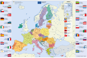
Map of the European Union, Dutch (or in another European language), in A4 format.
You will find this information per country: flag, capital, area, population, currency.
You can download or order this map.
Translated by
Downloadable resource
-
Maurice Ravel's Bolero: Animated film

The Bolero is never monotonous for your young audience again with this fine animation film. Musical notes develop into musicians and are also the characters in the story.
The animation itself was created by Simon Brethé with music by the Romantic …
Translated by
Video (13)Teacher -
Our planet, our future: Informative site with worksheets

Our planet, our future is an online platform that can help young people to better understand the causes and consequences of climate change, while offering solutions on how to make our society climate-friendly. The platform combines science, …
Translated by
Downloadable resource (3)Organisation, company, NPO -
Seterra Geography

With this app you can practice continents, countries, rivers, capitals, rivers on a blind map.
After selecting a card, you must click on what is requested by time.
Translated by
App or software (5)Teacher -
Global Footprint calculator

The user chooses its country on a map and the language to use. After he has to answer a series of questions about he's consumption habits, mobility, food, etc.
In the end he will see the results of he's ecological footprint in terms of the number of …
WebsiteTeacher, ICT co-ordinator, … -
Toporopa: Topography of Europe

Toporopa is intended for anyone who wants to get to know the topography of Europe better. Various things can be practiced here: Euro countries, rivers, mountain ranges, monarchies, seas, metropolises, islands, capitals, volcanoes, flags, ports, …
Translated by
Website (19)Teacher -
European Kids Site

Once registered, you can search for songs, games and stories on this English-language portal for children up to 6 years old...
Translated by
WebsiteTeacher, Schoolboard, … -
Scientix: European network for science education

Scientix is an engaged community for scientific education in Europe. They aim to promote collaboration between STEM educators, education researchers and policy makers, with the aim of inspiring students to pursue careers in science, technology, …
Translated by
Website (3)
-
Database of photos related to Classical Antiquity

It's actually a 'group' on the very extensive Flickr photo site. Photos (about 12000) are collected in this group, all of which relate to Classical Antiquity.
The interesting thing is that the photos all come from amateur photographers …
Translated by
Website (7)Teacher
Yummmm… cookies!
We don't like being tracked either. That's why we're concerned about your privacy.
Necessary cookies: for the proper operation of the website.
Functional cookies: for your convenience. recommended
Social media cookies: to view embedded media such as videos from YouTube, Facebook … recommended
Statistical cookies: for anonymous data collection to enhance user experience.