-
Travle: Geographical knowledge

Travle is an interactive game where you get two countries on a map or two provinces. Your job is to get from one to the other. You do this by typing the name of a country or province and adding it to the map, on which your route becomes visible. …
Translated by
 Interactive exerciseTeacher, ICT co-ordinator
 -
Seterra Geography: Blind map exercises

With the exercises on this website you can practice continents, countries, rivers, capitals, rivers on a blind map.
After selecting a card, you must click on what is requested by time.
Translated by
Interactive exercise (3)Teacher -
Scientix: European network for science education

Scientix is an engaged community for scientific education in Europe. They aim to promote collaboration between STEM educators, education researchers and policy makers, with the aim of inspiring students to pursue careers in science, technology, …
Translated by
Website (3)
-
FluidDraw: Educational License

Teachers and students can request a free license for FluidDraw via a contact form. This software has been developed to draw pneumatic and electrical circuit diagrams.
Translated by
App or software
-
QElectroTech: Drawing electrical diagrams

QElectroTech is open source software to draw electrical diagrams free of charge. In addition to the software, you will also find a manual, videos and sample diagrams on this website.
Translated by
App or softwareTeacher -
European Union: Map
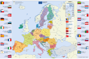
Map of the European Union, Dutch (or in another European language), in A4 format.
You will find this information per country: flag, capital, area, population, currency.
You can download or order this map.
Translated by
Downloadable resource
-
Our planet, our future: Informative site with worksheets

Our planet, our future is an online platform that can help young people to better understand the causes and consequences of climate change, while offering solutions on how to make our society climate-friendly. The platform combines science, …
Translated by
Downloadable resource (3)Organisation, company, NPO -
Seterra Geography

With this app you can practice continents, countries, rivers, capitals, rivers on a blind map.
After selecting a card, you must click on what is requested by time.
Translated by
App or software (5)Teacher -
Physical Experiments: Animations and Simulations

Here you will find simulations about various parts of the physics subject.
Translated by
WebsiteOther function -
Open AGH: Polish instructional database

On this Polish instructional site you will find courses, tests, exercises, presentations and simulations for different subjects. The teaching materials created by teachers or college students.
The site focuses mainly on scientific subjects and …
Translated by
WebsiteTeacher -
Toporopa: Topography of Europe

Toporopa is intended for anyone who wants to get to know the topography of Europe better. Various things can be practiced here: Euro countries, rivers, mountain ranges, monarchies, seas, metropolises, islands, capitals, volcanoes, flags, ports, …
Translated by
Website (19)Teacher
Yummmm… cookies!
We don't like being tracked either. That's why we're concerned about your privacy.
Necessary cookies: for the proper operation of the website.
Functional cookies: for your convenience. recommended
Social media cookies: to view embedded media such as videos from YouTube, Facebook … recommended
Statistical cookies: for anonymous data collection to enhance user experience.